Geolocate

Loupoigne topographic map

Interactive map

Click on the map to display elevation.

About this map

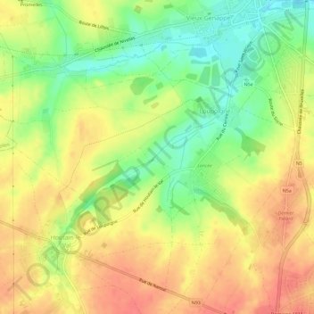
Name: Loupoigne topographic map, elevation, terrain.

Location: Loupoigne, Genepiën, Nijvel, Waals-Brabant, Wallonië, 1471, België (50.57550 4.40005 50.60926 4.45684)

Average elevation: 436 ft

Minimum elevation: 328 ft

Maximum elevation: 518 ft

Other topographic maps

Click on a map to view its topography, its elevation and its terrain.

Houtain-le-Val

België > Wallonië > Genepiën

Houtain-le-Val, Genepiën, Waals-Brabant, Wallonië, 1476, België

Average elevation: 492 ft

Bousval

België > Wallonië > Genepiën

Bousval, Genepiën, Nijvel, Waals-Brabant, Wallonië, 1470, België

Average elevation: 358 ft

Ways

België > Wallonië > Genepiën

Ways, Genepiën, Nijvel, Waals-Brabant, Wallonië, 1474, België

Average elevation: 397 ft

Baisy-Thy

België > Wallonië > Genepiën

Baisy-Thy, Genepiën, Nijvel, Waals-Brabant, Wallonië, 1470, België

Average elevation: 417 ft