
Make a donation
Gear up for your next adventure:
As an Amazon Associate, this site earns from qualifying purchases at no extra cost to you.
Springettsbury Township topographic map
Click on the map to display elevation.
Make a donation
Gear up for your next adventure:
As an Amazon Associate, this site earns from qualifying purchases at no extra cost to you.
About this map
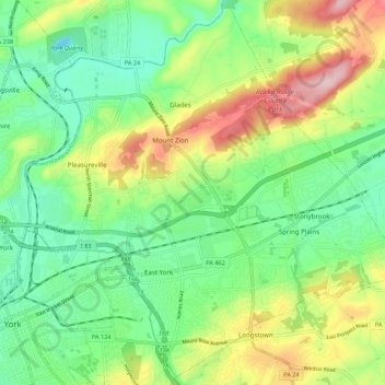
Name: Springettsbury Township topographic map, elevation, terrain.
Average elevation: 522 ft
Minimum elevation: 240 ft
Maximum elevation: 1,030 ft
York County trails, hiking, mountain biking, running and outdoor activities
Make a donation
Gear up for your next adventure:
As an Amazon Associate, this site earns from qualifying purchases at no extra cost to you.
Other topographic maps
Click on a map to view its topography, its elevation and its terrain.
Rosemount
United States > Pennsylvania > York County > Spring Garden Township
Average elevation: 548 ft
Make a donation
Gear up for your next adventure:
As an Amazon Associate, this site earns from qualifying purchases at no extra cost to you.
Hanover Junction
United States > Pennsylvania > York County > North Codorus Township
Average elevation: 614 ft
Strickhousers
United States > Pennsylvania > York County > North Codorus Township
Average elevation: 673 ft
Make a donation
Gear up for your next adventure:
As an Amazon Associate, this site earns from qualifying purchases at no extra cost to you.
Bass Lake
United States > Pennsylvania > York County > Newberry Township > Valley Green
Average elevation: 469 ft
Starview
United States > Pennsylvania > York County > East Manchester Township
Average elevation: 509 ft
Make a donation
Gear up for your next adventure:
As an Amazon Associate, this site earns from qualifying purchases at no extra cost to you.
Pleasureville
United States > Pennsylvania > York County > Springettsbury Township
Average elevation: 476 ft
East York
United States > Pennsylvania > York County > Springettsbury Township
Average elevation: 469 ft
Make a donation
Gear up for your next adventure:
As an Amazon Associate, this site earns from qualifying purchases at no extra cost to you.
Stoverstown
United States > Pennsylvania > York County > North Codorus Township
Average elevation: 561 ft
Spring Plains
United States > Pennsylvania > York County > Springettsbury Township
Average elevation: 495 ft
Make a donation
Gear up for your next adventure:
As an Amazon Associate, this site earns from qualifying purchases at no extra cost to you.
Spring Plains
United States > Pennsylvania > York County > Springettsbury Township
Average elevation: 495 ft
Make a donation
Gear up for your next adventure:
As an Amazon Associate, this site earns from qualifying purchases at no extra cost to you.
Delta Ridge
United States > Pennsylvania > York County > Peach Bottom Township
Average elevation: 492 ft
Ore Valley
United States > Pennsylvania > York County > York Township > Ore Valley
Average elevation: 663 ft
Make a donation
Gear up for your next adventure:
As an Amazon Associate, this site earns from qualifying purchases at no extra cost to you.