
Make a donation
Gear up for your next adventure:
As an Amazon Associate, this site earns from qualifying purchases at no extra cost to you.
Klei topographic map
Click on the map to display elevation.
Make a donation
Gear up for your next adventure:
As an Amazon Associate, this site earns from qualifying purchases at no extra cost to you.
About this map
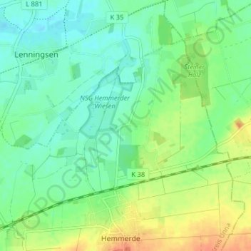
Name: Klei topographic map, elevation, terrain.
Location: Klei, Unna, Kreis Unna, Nordrhein-Westfalen, Deutschland (51.54487 7.79255 51.58487 7.83255)
Average elevation: 266 ft
Minimum elevation: 220 ft
Maximum elevation: 338 ft
Make a donation
Gear up for your next adventure:
As an Amazon Associate, this site earns from qualifying purchases at no extra cost to you.
Other topographic maps
Click on a map to view its topography, its elevation and its terrain.
Unna
Deutschland > Nordrhein-Westfalen > Kreis Unna > Unna
Unna liegt etwa 15 km östlich von Dortmund am östlichen Rand des Ruhrgebiets, am Westfälischen Hellweg und damit in der Hellwegbörde, die sich zwischen den Flüssen Ruhr und Lippe erstreckt. Das Stadtgebiet umfasst Höhenlagen von 65 m (Afferder Bach) bis zu 225 m (Hemmerder Schelk) über NN.
Average elevation: 374 ft