
Make a donation
Gear up for your next adventure:
As an Amazon Associate, this site earns from qualifying purchases at no extra cost to you.
Donnelsville topographic map
Click on the map to display elevation.
Make a donation
Gear up for your next adventure:
As an Amazon Associate, this site earns from qualifying purchases at no extra cost to you.
About this map
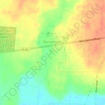
Name: Donnelsville topographic map, elevation, terrain.
Location: Donnelsville, Clark County, Ohio, 45319, United States (39.91067 -83.95328 39.92063 -83.93634)
Average elevation: 948 ft
Minimum elevation: 863 ft
Maximum elevation: 1,017 ft
Clark County trails, hiking, mountain biking, running and outdoor activities
Make a donation
Gear up for your next adventure:
As an Amazon Associate, this site earns from qualifying purchases at no extra cost to you.
Other topographic maps
Click on a map to view its topography, its elevation and its terrain.
Make a donation
Gear up for your next adventure:
As an Amazon Associate, this site earns from qualifying purchases at no extra cost to you.
Harmony Estates Mobile Home Park
United States > Ohio > Clark County > Harmony Estates Mobile Home Park
Average elevation: 1,102 ft