Geolocate

Nideggen topographic map

Click on the map to display elevation.

About this map

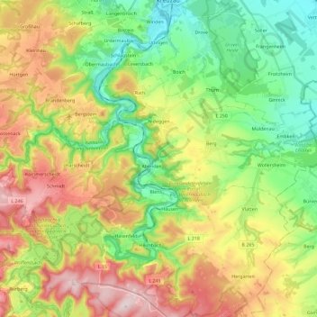
Name: Nideggen topographic map, elevation, terrain.

Location: Nideggen, Kreis Düren, North Rhine-Westphalia, 52385, Germany (50.63566 6.37207 50.71257 6.60145)

Average elevation: 984 ft

Minimum elevation: 463 ft

Maximum elevation: 1,752 ft

Other topographic maps

Click on a map to view its topography, its elevation and its terrain.

Hambach

Germany > North Rhine-Westphalia > Kreis Düren

Average elevation: 364 ft

Pier

Germany > North Rhine-Westphalia > Kreis Düren

Average elevation: 522 ft

Hasenfeld

Germany > North Rhine-Westphalia > Kreis Düren

Average elevation: 1,043 ft

Duren

Germany > North Rhine-Westphalia > Kreis Düren > Duren > Duren

Average elevation: 443 ft

Gear up for your next adventure:

🔭Compact Binoculars - HD vision for scouting terrain and identifying distant landmarks
🎒Gear Packing Cubes - Organize your backpack efficiently
🏕️Family Camping Gear - Essentials for group camping trips
🧴Hand Sanitizer - Keep hands clean while hiking
🌐World Map Poster - Decorative world maps with topographic info

As an Amazon Associate, this site earns from qualifying purchases at no extra cost to you.