
Lattimore topographic map
Click on the map to display elevation.
About this map
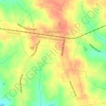
Name: Lattimore topographic map, elevation, terrain.
Location: Lattimore, Cleveland County, North Carolina, United States (35.30101 -81.67096 35.32458 -81.64991)
Average elevation: 889 ft
Minimum elevation: 791 ft
Maximum elevation: 955 ft
Cleveland County trails, hiking, mountain biking, running and outdoor activities
Other topographic maps
Click on a map to view its topography, its elevation and its terrain.
Osborne Apartments
United States > North Carolina > Cleveland County > Shelby
Average elevation: 840 ft