
Surachand topographic map
Click on the map to display elevation.
About this map
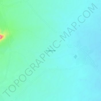
Name: Surachand topographic map, elevation, terrain.
Average elevation: 121 ft
Minimum elevation: 62 ft
Maximum elevation: 456 ft
Other topographic maps
Click on a map to view its topography, its elevation and its terrain.
Mithi
Pakistan > Sindh > Tharparkar District
The town is located at 24°74'0N 69°80'0E with an altitude of 28 meters (92 feet). It lies 450 kilometers from Karachi and is located in a desert area. The geography of Mithi is characterized by its arid landscape, typical of the Thar Desert, which influences the climate, agriculture, and daily life in the…
Average elevation: 184 ft