Geolocate

Wilton topographic map

Click on the map to display elevation.

About this map

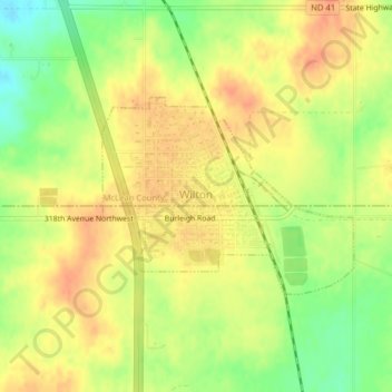
Name: Wilton topographic map, elevation, terrain.

Location: Wilton, McLean County, North Dakota, United States (47.15186 -100.79617 47.16546 -100.77065)

Average elevation: 2,159 ft

Minimum elevation: 2,077 ft

Maximum elevation: 2,208 ft

McLean County trails, hiking, mountain biking, running and outdoor activities

Other topographic maps

Click on a map to view its topography, its elevation and its terrain.

Falkirk

United States > North Dakota > McLean County

Average elevation: 1,880 ft

Gear up for your next adventure:

🥇GPS Hiking Watch - Multi‑sport GPS watch with navigation and trail tracking
🛰️Satellite Messengers - Emergency SOS and two-way messaging for off-grid adventures
🦶Carbon Trekking Poles - Reduce knee impact on steep descents with ultra-light poles
🔦Compact Flashlight - Reliable flashlight for emergencies
🧣Hiking Neck Gaiter - Multi‑use neck protection for outdoor weather

As an Amazon Associate, this site earns from qualifying purchases at no extra cost to you.