
Thank you for supporting this site ❤️
Make a donation
Make a donation
Gear up for your next adventure:
As an Amazon Associate, this site earns from qualifying purchases at no extra cost to you.
Martiñán topographic map
Click on the map to display elevation.
Thank you for supporting this site ❤️
Make a donation
Make a donation
Gear up for your next adventure:
As an Amazon Associate, this site earns from qualifying purchases at no extra cost to you.
About this map
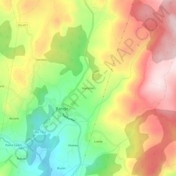
Name: Martiñán topographic map, elevation, terrain.
Location: Martiñán, Bande, A Baixa Limia, Ourense, Galicia, 32840, Spain (42.01625 -7.98686 42.05625 -7.94686)
Average elevation: 2,723 ft
Minimum elevation: 2,060 ft
Maximum elevation: 3,369 ft
Thank you for supporting this site ❤️
Make a donation
Make a donation
Gear up for your next adventure:
As an Amazon Associate, this site earns from qualifying purchases at no extra cost to you.