
Make a donation
Gear up for your next adventure:
As an Amazon Associate, this site earns from qualifying purchases at no extra cost to you.
Loganton topographic map
Click on the map to display elevation.
Make a donation
Gear up for your next adventure:
As an Amazon Associate, this site earns from qualifying purchases at no extra cost to you.
About this map
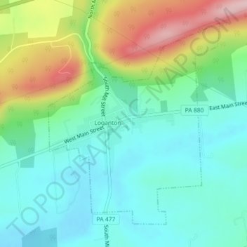
Name: Loganton topographic map, elevation, terrain.
Location: Loganton, Clinton County, Pennsylvania, United States (41.02358 -77.31522 41.04560 -77.29038)
Average elevation: 1,417 ft
Minimum elevation: 1,191 ft
Maximum elevation: 1,942 ft
Clinton County trails, hiking, mountain biking, running and outdoor activities
Make a donation
Gear up for your next adventure:
As an Amazon Associate, this site earns from qualifying purchases at no extra cost to you.
Other topographic maps
Click on a map to view its topography, its elevation and its terrain.
Farrandsville
United States > Pennsylvania > Clinton County > Colebrook Township
Average elevation: 961 ft
Tylersville
United States > Pennsylvania > Clinton County > Logan Township
Average elevation: 1,493 ft
Make a donation
Gear up for your next adventure:
As an Amazon Associate, this site earns from qualifying purchases at no extra cost to you.
Woolrich
United States > Pennsylvania > Clinton County > Pine Creek Township
Average elevation: 951 ft
Riverview
United States > Pennsylvania > Clinton County > Bald Eagle Township > Riverview
Average elevation: 968 ft