Geolocate

Fishpond topographic map

Click on the map to display elevation.

About this map

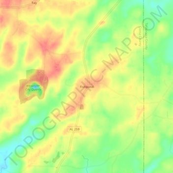
Name: Fishpond topographic map, elevation, terrain.

Location: Fishpond, Coosa County, Alabama, United States (32.84790 -86.04330 32.88790 -86.00330)

Average elevation: 676 ft

Minimum elevation: 564 ft

Maximum elevation: 764 ft

Coosa County trails, hiking, mountain biking, running and outdoor activities

Other topographic maps

Click on a map to view its topography, its elevation and its terrain.

Goodwater

United States > Alabama > Coosa County

Average elevation: 823 ft

Kellyton

United States > Alabama > Coosa County

Average elevation: 738 ft

Rockford

United States > Alabama > Coosa County

Average elevation: 725 ft

Gear up for your next adventure:

👟Men's Trail Runners - Lightweight footwear for fast-paced exploration and light hiking
🪶Fire Starter Kit - Reliable fire starter for survival and camping
🍳Camping Cook Set - Complete cookware for outdoor meals
🖼️Topo Map Wall Art - Decorative topographic prints of famous peaks and regions
🦟Ultrasonic Repellers - Create a bug-free zone at your camp or rest stop

As an Amazon Associate, this site earns from qualifying purchases at no extra cost to you.