
Tosagua topographic map
Interactive map
Click on the map to display elevation.
About this map
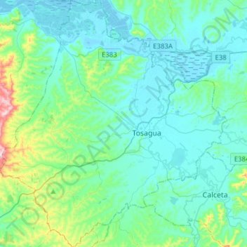
Name: Tosagua topographic map, elevation, terrain.
Location: Tosagua, Manabí, Ecuador (-0.90139 -80.38383 -0.64980 -80.15186)
Average elevation: 217 ft
Minimum elevation: -10 ft
Maximum elevation: 1,430 ft
Other topographic maps
Click on a map to view its topography, its elevation and its terrain.
La Estancilla
La Estancilla, Parroquia Angel Pedro Giler, Tosagua, Manabí, Ecuador
Average elevation: 52 ft
Aguas Coloradas
Ecuador > Manabí > Chone > Chone
Aguas Coloradas, Chone, Manabí, Ecuador
Average elevation: 141 ft