Geolocate

Vernon Center topographic map

Click on the map to display elevation.

About this map

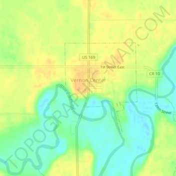
Name: Vernon Center topographic map, elevation, terrain.

Location: Vernon Center, Blue Earth County, Minnesota, United States (43.95370 -94.17415 43.96760 -94.15868)

Average elevation: 1,004 ft

Minimum elevation: 948 ft

Maximum elevation: 1,053 ft

Blue Earth County trails, hiking, mountain biking, running and outdoor activities

Other topographic maps

Click on a map to view its topography, its elevation and its terrain.

Garden City

United States > Minnesota > Blue Earth County

Average elevation: 974 ft

Benning

United States > Minnesota > Blue Earth County > Mankato

Average elevation: 843 ft

Beauford

United States > Minnesota > Blue Earth County

Average elevation: 1,004 ft

Gear up for your next adventure:

💧Water Filtration Bottles - Safely drink from streams and lakes while exploring
🌲Outdoor Survival Books - Best books on survival skills
🧦Merino Wool Socks - Moisture-wicking, blister-preventing socks for long treks
🪶Paracord Bracelet - Survival bracelet with built‑in tools
🧥Waterproof Jacket for Hiking - Breathable and rugged rain jacket for outdoor excursions

As an Amazon Associate, this site earns from qualifying purchases at no extra cost to you.