
Shah Mansur District topographic map
Interactive map
Click on the map to display elevation.
About this map
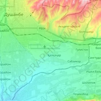
Name: Shah Mansur District topographic map, elevation, terrain.
Location: Shah Mansur District, Dushanbe, 734000, Tajikistan (38.49418 68.76880 38.58933 68.88710)
Average elevation: 2,648 ft
Minimum elevation: 2,375 ft
Maximum elevation: 3,442 ft
Dushanbe is the capital and largest city of Tajikistan. As of January 2022, Dushanbe had a population of 1,201,800 and that population was largely Tajik. Until 1929, the city was known in Russian as Dyushambe, and from 1929 to 1961 as Stalinabad, after Joseph Stalin. Dushanbe is located in the Gissar Valley, bounded by the Gissar Range in the north and east and the Babatag, Aktau, Rangontau and Karatau mountains in the south, and has an elevation of 750–930 m. The city is divided into four districts, all named after Persian historical figures: Ismail Samani, Avicenna, Ferdowsi, and Shah Mansur.
Other topographic maps
Click on a map to view its topography, its elevation and its terrain.
Ismail Samani District
Ismail Samani District, Dushanbe, 734000, Tajikistan
Average elevation: 3,717 ft