
Ismail Samani District topographic map
Interactive map
Click on the map to display elevation.
About this map
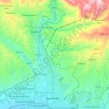
Name: Ismail Samani District topographic map, elevation, terrain.
Location: Ismail Samani District, Dushanbe, 734000, Tajikistan (38.56156 68.76236 38.70684 68.83146)
Average elevation: 3,717 ft
Minimum elevation: 2,556 ft
Maximum elevation: 7,106 ft
Other topographic maps
Click on a map to view its topography, its elevation and its terrain.
Shah Mansur District
Shah Mansur District, Dushanbe, 734000, Tajikistan
Average elevation: 2,648 ft