
Täsch topographic map
Click on the map to display elevation.
About this map
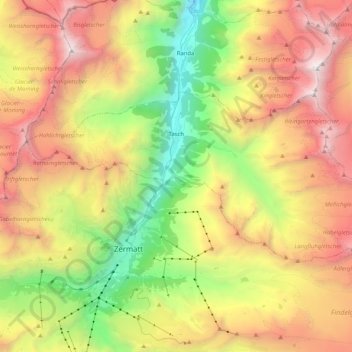
Name: Täsch topographic map, elevation, terrain.
Location: Täsch, Visp, Wallis, 3929, Switzerland (46.01622 7.69006 46.08467 7.89458)
Average elevation: 9,222 ft
Minimum elevation: 4,213 ft
Maximum elevation: 14,869 ft
Other topographic maps
Click on a map to view its topography, its elevation and its terrain.
Zermatt
Switzerland > Wallis > Visp > Zermatt > Zermatt
It lies at the upper end of Mattertal at an elevation of 1,620 m (5,310 ft), at the foot of Switzerland's highest peaks. It lies about 10 km (6.2 mi) from the over 3,292 m (10,801 ft) high Theodul Pass bordering Italy. Zermatt is the southernmost commune of the German Sprachraum.
Average elevation: 8,100 ft