Geolocate

Weyers Cave topographic map

Click on the map to display elevation.

About this map

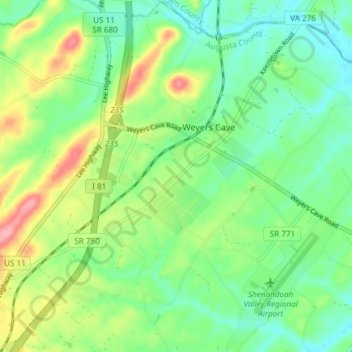
Name: Weyers Cave topographic map, elevation, terrain.

Location: Weyers Cave, Augusta County, Virginia, 24486, United States (38.25422 -78.94310 38.30948 -78.88269)

Average elevation: 1,194 ft

Minimum elevation: 1,076 ft

Maximum elevation: 1,417 ft

Augusta County trails, hiking, mountain biking, running and outdoor activities

Gear up for your next adventure:

🛶Inflatable Kayak - Portable kayak for rivers, lakes, and expeditions
🧤Hiking Gloves - Protective gloves for rugged trails
🪶Multi‑Purpose Knife - Useful blade for camp and trail
🎒Trail Energy Bars - High‑calorie bars for hiking energy
🪶Thermal Camp Blanket - Extra warmth for cold nights

As an Amazon Associate, this site earns from qualifying purchases at no extra cost to you.