
白沙镇 topographic map
Interactive map
Click on the map to display elevation.
About this map
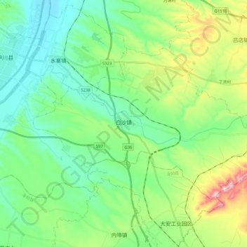
Name: 白沙镇 topographic map, elevation, terrain.
Location: 白沙镇, 伊川县, 洛阳市, 河南省, 中国 (34.32693 112.44857 34.43171 112.65496)
Average elevation: 988 ft
Minimum elevation: 564 ft
Maximum elevation: 2,139 ft
Other topographic maps
Click on a map to view its topography, its elevation and its terrain.