
Make a donation
Gear up for your next adventure:
As an Amazon Associate, this site earns from qualifying purchases at no extra cost to you.
Norderwöhrden topographic map
Click on the map to display elevation.
Make a donation
Gear up for your next adventure:
As an Amazon Associate, this site earns from qualifying purchases at no extra cost to you.
Norderwöhrden
Vor dem Siedlungsbeginn am Ende des 7. Jahrhunderts wuchs auf der Wurt vor allem Schilfrohr, das für die Anlage der Hofstellen und der saisonalen, nur im Sommer bewirtschafteten Äcker mit Hafer, Gerste und Leinanbau Platz machte. Vor allem aber nutzten die Bewohner die umliegende Salzmarsch als Viehweide für Rinder, Schafe und Pferde. Die Vegetation bestand aus Brackwasserpflanzen Milchkraut, Andeln, Salzbinsen, Schuppenmieren, Röhrkohl und auf etwas höhergelegenen Stellen Seggen, Straußgras und ebenfalls Schilfrohr.
Make a donation
Gear up for your next adventure:
As an Amazon Associate, this site earns from qualifying purchases at no extra cost to you.
About this map
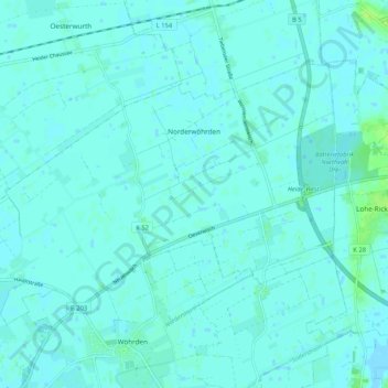
Name: Norderwöhrden topographic map, elevation, terrain.
Average elevation: 7 ft
Minimum elevation: -7 ft
Maximum elevation: 36 ft
Make a donation
Gear up for your next adventure:
As an Amazon Associate, this site earns from qualifying purchases at no extra cost to you.
Other topographic maps
Click on a map to view its topography, its elevation and its terrain.
Make a donation
Gear up for your next adventure:
As an Amazon Associate, this site earns from qualifying purchases at no extra cost to you.
WKK Ententeich
Deutschland > Schleswig-Holstein > Dithmarschen > Heide > Hochfeld
Average elevation: 26 ft
Make a donation
Gear up for your next adventure:
As an Amazon Associate, this site earns from qualifying purchases at no extra cost to you.
Make a donation
Gear up for your next adventure:
As an Amazon Associate, this site earns from qualifying purchases at no extra cost to you.
Zippelkoog
Deutschland > Schleswig-Holstein > Dithmarschen > Helse > Zippelkoog
Average elevation: 3 ft
Make a donation
Gear up for your next adventure:
As an Amazon Associate, this site earns from qualifying purchases at no extra cost to you.
Poppenwurth
Deutschland > Schleswig-Holstein > Dithmarschen > Oesterwurth > Poppenwurth
Average elevation: 7 ft
Make a donation
Gear up for your next adventure:
As an Amazon Associate, this site earns from qualifying purchases at no extra cost to you.
Oldörpen
Deutschland > Schleswig-Holstein > Dithmarschen > Tensbüttel-Röst > Tensbüttel > Oldörpen
Average elevation: 56 ft