Geolocate

Irene topographic map

Click on the map to display elevation.

About this map

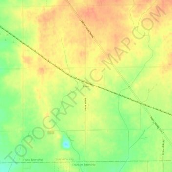
Name: Irene topographic map, elevation, terrain.

Location: Irene, Flora Township, Boone County, Illinois, United States (42.15030 -88.92038 42.19030 -88.88038)

Average elevation: 817 ft

Minimum elevation: 728 ft

Maximum elevation: 869 ft

Boone County trails, hiking, mountain biking, running and outdoor activities

Other topographic maps

Click on a map to view its topography, its elevation and its terrain.

Candlewick Lake

United States > Illinois > Boone County

Average elevation: 919 ft

Spring Township

United States > Illinois > Boone County

Average elevation: 830 ft

Flora Township

United States > Illinois > Boone County

Average elevation: 810 ft

Timberlane

United States > Illinois > Boone County

Average elevation: 886 ft

Bonus Township

United States > Illinois > Boone County

Average elevation: 807 ft

Leroy Township

United States > Illinois > Boone County

Average elevation: 958 ft

Poplar Grove

United States > Illinois > Boone County

Average elevation: 863 ft

Capron

United States > Illinois > Boone County

Average elevation: 919 ft

Caledonia

United States > Illinois > Boone County

Average elevation: 932 ft

Gear up for your next adventure:

🎒Outdoor Daypacks - Lightweight backpacks designed for carrying maps and essential gear
🔭Telescopic Hiking Pole - Adjustable pole for hiking stability
🖼️Topo Map Wall Art - Decorative topographic prints of famous peaks and regions
🌧️Backpack Rain Cover - Keep gear dry in wet weather
🪓Survival Multi‑Tool - Versatile tool for camp and trail tasks

As an Amazon Associate, this site earns from qualifying purchases at no extra cost to you.