Geolocate

Eldred topographic map

Click on the map to display elevation.

About this map

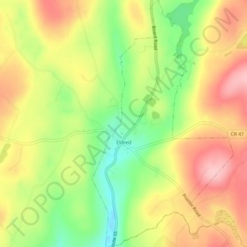
Name: Eldred topographic map, elevation, terrain.

Location: Eldred, Town of Highland, Sullivan County, New York, United States (41.51348 -74.88956 41.54543 -74.86503)

Average elevation: 1,152 ft

Minimum elevation: 876 ft

Maximum elevation: 1,394 ft

Sullivan County trails, hiking, mountain biking, running and outdoor activities

Other topographic maps

Click on a map to view its topography, its elevation and its terrain.

Aden

United States > New York > Sullivan County > Town of Neversink

Average elevation: 1,729 ft

Mount Prosper

United States > New York > Sullivan County

Average elevation: 1,434 ft

Wolf Lake

United States > New York > Sullivan County

Average elevation: 1,549 ft

Hawks Nest

United States > New York > Sullivan County

Average elevation: 1,460 ft

Phillipsport

United States > New York > Sullivan County

Average elevation: 866 ft

South Fallsburg

United States > New York > Sullivan County

Average elevation: 1,322 ft

Livingston Manor

United States > New York > Sullivan County

Average elevation: 1,709 ft

Mount Vernon

United States > New York > Sullivan County

Average elevation: 1,365 ft

Parkston

United States > New York > Sullivan County > Town of Rockland

Average elevation: 1,860 ft

North Branch

United States > New York > Sullivan County

Average elevation: 1,348 ft

Yulan

United States > New York > Sullivan County

Average elevation: 1,148 ft

Glen Spey

United States > New York > Sullivan County

Average elevation: 1,276 ft

East Hill

United States > New York > Sullivan County

Average elevation: 1,404 ft

Barryville

United States > New York > Sullivan County

Average elevation: 928 ft

Long Eddy

United States > New York > Sullivan County

Average elevation: 1,273 ft

Anderson

United States > New York > Sullivan County > Town of Rockland

Average elevation: 2,008 ft

Anderson

United States > New York > Sullivan County > Town of Rockland

Average elevation: 2,008 ft

Glen Spey

United States > New York > Sullivan County

Average elevation: 1,276 ft

Gear up for your next adventure:

🗺️NatGeo Topo Maps - High-quality waterproof printed topographic maps of US Parks
🧷Carabiner Set - Durable clips for gear attachment
📷Action Cameras - Rugged cameras to document your journeys across rugged terrain
🧭Pro Hiking Compasses - High-accuracy liquid-filled compasses for topographic orientation
🧭Outdoor Navigation Book - Learn advanced navigation skills

As an Amazon Associate, this site earns from qualifying purchases at no extra cost to you.