
Make a donation
Gear up for your next adventure:
As an Amazon Associate, this site earns from qualifying purchases at no extra cost to you.
Dermbach topographic map
Click on the map to display elevation.
Make a donation
Gear up for your next adventure:
As an Amazon Associate, this site earns from qualifying purchases at no extra cost to you.
Dermbach
Dermbach liegt im geographischen Siegerland und an der Grenze zu Struthütten im historischen Siegerland. Der Ort liegt auf einer Höhe zwischen 280 und 340 m und hat eine Gemarkungsfläche von 4,41 km². Durchflossen wird er vom gleichnamigen Bach, der bei Herdorf in die Heller mündet. Die höchste Erhebung in der Nähe des Ortes ist der Windhahn mit 517,2 m. In der Nähe liegen außerdem noch der Kohlenberg und der Schiffenberg.
Make a donation
Gear up for your next adventure:
As an Amazon Associate, this site earns from qualifying purchases at no extra cost to you.
About this map
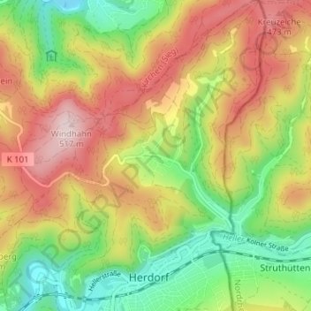
Name: Dermbach topographic map, elevation, terrain.
Average elevation: 1,171 ft
Minimum elevation: 679 ft
Maximum elevation: 1,716 ft
Make a donation
Gear up for your next adventure:
As an Amazon Associate, this site earns from qualifying purchases at no extra cost to you.