Geolocate
👉 Easily get elevation data in JSON, GeoTIFF and KML formats using Elevation API
Thank you for supporting this site ❤️
Make a donation

Chequest topographic map

Click on the map to display elevation.

About this map

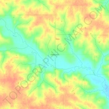
Name: Chequest topographic map, elevation, terrain.

Location: Chequest, Davis County, Iowa, United States (40.80835 -92.26574 40.84835 -92.22574)

Average elevation: 761 ft

Minimum elevation: 682 ft

Maximum elevation: 820 ft

Davis County trails, hiking, mountain biking, running and outdoor activities

Other topographic maps

Click on a map to view its topography, its elevation and its terrain.

Pulaski

United States > Iowa > Davis County

Average elevation: 820 ft

Drakesville

United States > Iowa > Davis County

Average elevation: 860 ft

Floris

United States > Iowa > Davis County

Average elevation: 715 ft

Gear up for your next adventure:

📦Gear Storage Bags - Organize and protect outdoor equipment
🧥Men's Rain Shells - Premium waterproof and breathable jackets for mountain weather
🪑Ultralight Camp Chairs - Portable seating for resting after a long day of mapping
🌡️Portable Weather Meter - Track weather conditions on the trail
🧦Merino Wool Socks - Moisture-wicking, blister-preventing socks for long treks

As an Amazon Associate, this site earns from qualifying purchases at no extra cost to you.