
Make a donation
Gear up for your next adventure:
As an Amazon Associate, this site earns from qualifying purchases at no extra cost to you.
Lower Gwynedd Township topographic map
Click on the map to display elevation.
Make a donation
Gear up for your next adventure:
As an Amazon Associate, this site earns from qualifying purchases at no extra cost to you.
About this map
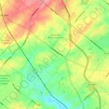
Name: Lower Gwynedd Township topographic map, elevation, terrain.
Average elevation: 328 ft
Minimum elevation: 187 ft
Maximum elevation: 486 ft
Montgomery County trails, hiking, mountain biking, running and outdoor activities
Make a donation
Gear up for your next adventure:
As an Amazon Associate, this site earns from qualifying purchases at no extra cost to you.
Other topographic maps
Click on a map to view its topography, its elevation and its terrain.
Eagleville
United States > Pennsylvania > Montgomery County > Lower Providence Township
Average elevation: 335 ft
Shirks Corner
United States > Pennsylvania > Montgomery County > Upper Salford Township
Average elevation: 262 ft
Perkiomen Place
United States > Pennsylvania > Montgomery County > East Greenville
Average elevation: 367 ft
Zieglersville
United States > Pennsylvania > Montgomery County > Lower Frederick
Average elevation: 272 ft
Make a donation
Gear up for your next adventure:
As an Amazon Associate, this site earns from qualifying purchases at no extra cost to you.
Fulmor
United States > Pennsylvania > Montgomery County > Upper Moreland Township
Average elevation: 259 ft
Morganville
United States > Pennsylvania > Montgomery County > Upper Moreland Township > Willow Grove
Average elevation: 266 ft
Willow Grove
United States > Pennsylvania > Montgomery County > Upper Moreland Township
Average elevation: 299 ft
Make a donation
Gear up for your next adventure:
As an Amazon Associate, this site earns from qualifying purchases at no extra cost to you.
Worcester
United States > Pennsylvania > Montgomery County > Worcester Township
Average elevation: 305 ft
Maple Glen
United States > Pennsylvania > Montgomery County > Upper Dublin Township
Average elevation: 335 ft
Rydal Park
United States > Pennsylvania > Montgomery County > Abington Township
Average elevation: 285 ft
Make a donation
Gear up for your next adventure:
As an Amazon Associate, this site earns from qualifying purchases at no extra cost to you.
Lafayette Park
United States > Pennsylvania > Montgomery County > Upper Merion Township > King of Prussia
Average elevation: 177 ft
Springtown
United States > Pennsylvania > Montgomery County > East Norriton Township
Average elevation: 243 ft
Bob White Farms
United States > Pennsylvania > Montgomery County > Upper Merion Township
Average elevation: 312 ft
Orvilla
United States > Pennsylvania > Montgomery County > Hatfield Township
Average elevation: 328 ft
Make a donation
Gear up for your next adventure:
As an Amazon Associate, this site earns from qualifying purchases at no extra cost to you.
Enfield
United States > Pennsylvania > Montgomery County > Springfield Township
Average elevation: 285 ft
Wyncote
United States > Pennsylvania > Montgomery County > Cheltenham Township
Average elevation: 302 ft
Mount Vernon Gardens
United States > Pennsylvania > Montgomery County > Abington Township
Average elevation: 305 ft
Make a donation
Gear up for your next adventure:
As an Amazon Associate, this site earns from qualifying purchases at no extra cost to you.
Fairoaks
United States > Pennsylvania > Montgomery County > Horsham Township > Horsham
Average elevation: 276 ft
Cynwyd Estates
United States > Pennsylvania > Montgomery County > Lower Merion Township
Average elevation: 262 ft
Perkiomenville
United States > Pennsylvania > Montgomery County > Marlborough Township
Average elevation: 318 ft
Make a donation
Gear up for your next adventure:
As an Amazon Associate, this site earns from qualifying purchases at no extra cost to you.
Wynmere Downs
United States > Pennsylvania > Montgomery County > Horsham Township
Average elevation: 322 ft
Mount Pleasant
United States > Pennsylvania > Montgomery County > Whitpain Township
Average elevation: 256 ft
Harleysville
United States > Pennsylvania > Montgomery County > Lower Salford Township
Average elevation: 299 ft
Meadowbrook
United States > Pennsylvania > Montgomery County > Abington Township
Average elevation: 217 ft
Make a donation
Gear up for your next adventure:
As an Amazon Associate, this site earns from qualifying purchases at no extra cost to you.
Ardmore
United States > Pennsylvania > Montgomery County > Lower Merion Township
Average elevation: 322 ft
Oak Summit
United States > Pennsylvania > Montgomery County > Cheltenham Township > Oak Summit
Average elevation: 318 ft
Oreland
United States > Pennsylvania > Montgomery County > Upper Dublin Township
Average elevation: 262 ft
Ridge Estates
United States > Pennsylvania > Montgomery County > Lower Pottsgrove Township > Ridge Estates
Average elevation: 302 ft
Make a donation
Gear up for your next adventure:
As an Amazon Associate, this site earns from qualifying purchases at no extra cost to you.
Sanatoga
United States > Pennsylvania > Montgomery County > Lower Pottsgrove Township
Average elevation: 226 ft
Harley Corners
United States > Pennsylvania > Montgomery County > East Norriton Township > Harley Corners
Average elevation: 344 ft
Cannon Run
United States > Pennsylvania > Montgomery County > King of Prussia > Cannon Run
Average elevation: 187 ft
Ardsley
United States > Pennsylvania > Montgomery County > Abington Township > Ardsley
Average elevation: 292 ft
Make a donation
Gear up for your next adventure:
As an Amazon Associate, this site earns from qualifying purchases at no extra cost to you.
Bryn Mawr
United States > Pennsylvania > Montgomery County > Lower Merion Township > Bryn Mawr
Average elevation: 358 ft
Gilbertsville
United States > Pennsylvania > Montgomery County > Douglass Township
Average elevation: 318 ft
Conshohocken Station
United States > Pennsylvania > Montgomery County > Upper Merion Township
Average elevation: 322 ft
Glenside
United States > Pennsylvania > Montgomery County > Abington Township
Average elevation: 308 ft
Make a donation
Gear up for your next adventure:
As an Amazon Associate, this site earns from qualifying purchases at no extra cost to you.
Flourtown
United States > Pennsylvania > Montgomery County > Springfield Township
Average elevation: 213 ft
Palm
United States > Pennsylvania > Montgomery County > Upper Hanover Township > Palm
Average elevation: 430 ft
Gladwyne Park
United States > Pennsylvania > Montgomery County > Lower Merion Township > Gladwyne
Average elevation: 315 ft
Meng Preserve
United States > Pennsylvania > Montgomery County > Schwenksville
Average elevation: 308 ft
Make a donation
Gear up for your next adventure:
As an Amazon Associate, this site earns from qualifying purchases at no extra cost to you.
Franconia
United States > Pennsylvania > Montgomery County > Franconia Township
Average elevation: 351 ft
Hollywood
United States > Pennsylvania > Montgomery County > Abington Township
Average elevation: 226 ft
Belmont Hills
United States > Pennsylvania > Montgomery County > Lower Merion Township
Average elevation: 236 ft