
Thank you for supporting this site ❤️
Make a donation
Make a donation
Gear up for your next adventure:
As an Amazon Associate, this site earns from qualifying purchases at no extra cost to you.
Fuenteheridos topographic map
Click on the map to display elevation.
Thank you for supporting this site ❤️
Make a donation
Make a donation
Gear up for your next adventure:
As an Amazon Associate, this site earns from qualifying purchases at no extra cost to you.
About this map
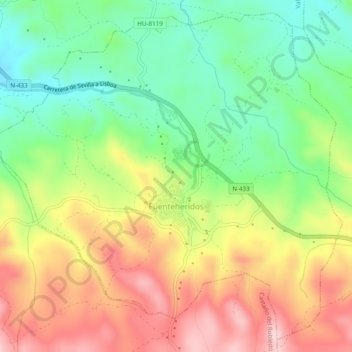
Name: Fuenteheridos topographic map, elevation, terrain.
Location: Fuenteheridos, Sierra de Huelva, Huelva, Andalusië, Spanje (37.88900 -6.68720 37.92446 -6.63881)
Average elevation: 2,336 ft
Minimum elevation: 1,955 ft
Maximum elevation: 2,799 ft
Thank you for supporting this site ❤️
Make a donation
Make a donation
Gear up for your next adventure:
As an Amazon Associate, this site earns from qualifying purchases at no extra cost to you.
Other topographic maps
Click on a map to view its topography, its elevation and its terrain.
Sierra de La Corbera
Spanje > Andalusië > Sierra de Huelva > Santa Olalla del Cala
Average elevation: 1,404 ft