Geolocate

Marcona topographic map

Click on the map to display elevation.

About this map

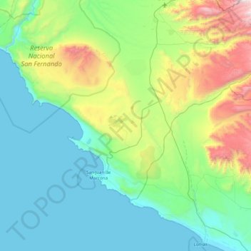
Name: Marcona topographic map, elevation, terrain.

Location: Marcona, Province of Nasca, Ica, Peru (-15.44378 -75.44148 -14.98754 -74.66427)

Average elevation: 1,601 ft

Minimum elevation: 0 ft

Maximum elevation: 7,703 ft

Other topographic maps

Click on a map to view its topography, its elevation and its terrain.

Fundo Pucuri

Peru > Ica > Montesierpe

Average elevation: 1,572 ft

Mendoza

Peru > Ica

Average elevation: 417 ft

Lindero

Peru > Ica > Palpa > Saramarca

Average elevation: 2,940 ft

Symbols

Peru > Ica > San Francisco > entrada al ingenio

Average elevation: 1,821 ft

Monkey

Peru > Ica > San Miguel de la Pascana

Average elevation: 1,490 ft

San Miguel de la Pascana

Peru > Ica

Average elevation: 1,332 ft

Gear up for your next adventure:

🌎3D Topographic Globes - Raised relief globes for a tactile understanding of geography
👓Polarized Sunglasses - Outdoor sunglasses for glare reduction
📱Heavy-Duty Phone Cases - Drop-proof and waterproof protection for outdoor navigation
🛠️Outdoor Gear Repair Kit - Essential tools to fix gear on the trail
🪶Thermal Camp Blanket - Extra warmth for cold nights

As an Amazon Associate, this site earns from qualifying purchases at no extra cost to you.