Geolocate

Enoch topographic map

Click on the map to display elevation.

About this map

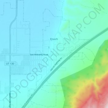
Name: Enoch topographic map, elevation, terrain.

Location: Enoch, Iron County, Utah, United States (37.73493 -113.07397 37.79491 -112.99962)

Average elevation: 5,804 ft

Minimum elevation: 5,453 ft

Maximum elevation: 7,854 ft

Iron County trails, hiking, mountain biking, running and outdoor activities

Other topographic maps

Click on a map to view its topography, its elevation and its terrain.

Cedar City

United States > Utah > Iron County > Cedar City > Cedar City

Average elevation: 6,847 ft

The Three Peaks

United States > Utah > Iron County

Average elevation: 5,869 ft

Strawberry Point

United States > Utah > Iron County

Average elevation: 7,992 ft

Gear up for your next adventure:

🧴Hand Sanitizer - Keep hands clean while hiking
🥾Women's Hiking Boots - Top-rated trail boots with ankle support and superior grip
📚Navigation Handbooks - Master the art of reading topographic maps and using a compass
📶Satellite Messenger - Communication device off‑grid
🧼Biodegradable Camping Soap - Eco‑friendly soap for outdoor hygiene

As an Amazon Associate, this site earns from qualifying purchases at no extra cost to you.