
Thank you for supporting this site ❤️
Make a donation
Make a donation
Gear up for your next adventure:
As an Amazon Associate, this site earns from qualifying purchases at no extra cost to you.
Waibakul topographic map
Click on the map to display elevation.
Thank you for supporting this site ❤️
Make a donation
Make a donation
Gear up for your next adventure:
As an Amazon Associate, this site earns from qualifying purchases at no extra cost to you.
About this map
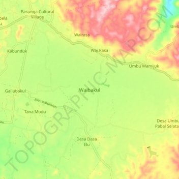
Name: Waibakul topographic map, elevation, terrain.
Location: Waibakul, Sumba Tengah, East Nusa Tenggara, Indonesia (-9.66162 119.55867 -9.58162 119.63867)
Average elevation: 1,467 ft
Minimum elevation: 1,106 ft
Maximum elevation: 1,847 ft
Thank you for supporting this site ❤️
Make a donation
Make a donation
Gear up for your next adventure:
As an Amazon Associate, this site earns from qualifying purchases at no extra cost to you.