
Make a donation
Gear up for your next adventure:
As an Amazon Associate, this site earns from qualifying purchases at no extra cost to you.
Shore Hills topographic map
Click on the map to display elevation.
Make a donation
Gear up for your next adventure:
As an Amazon Associate, this site earns from qualifying purchases at no extra cost to you.
About this map
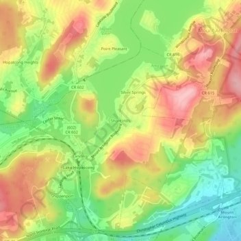
Name: Shore Hills topographic map, elevation, terrain.
Average elevation: 978 ft
Minimum elevation: 741 ft
Maximum elevation: 1,204 ft
Morris County trails, hiking, mountain biking, running and outdoor activities
Make a donation
Gear up for your next adventure:
As an Amazon Associate, this site earns from qualifying purchases at no extra cost to you.
Other topographic maps
Click on a map to view its topography, its elevation and its terrain.
Landing
United States > New Jersey > Morris County > Roxbury Township > Port Morris
Average elevation: 974 ft
Landing
United States > New Jersey > Morris County > Roxbury Township > Port Morris
Average elevation: 974 ft
Landing
United States > New Jersey > Morris County > Roxbury Township > Port Morris
Average elevation: 974 ft