
Make a donation
Gear up for your next adventure:
As an Amazon Associate, this site earns from qualifying purchases at no extra cost to you.
Osterklee topographic map
Click on the map to display elevation.
Make a donation
Gear up for your next adventure:
As an Amazon Associate, this site earns from qualifying purchases at no extra cost to you.
Osterklee
Osterklee ist ein Naturschutzgebiet an der Grenze zwischen der Münsterländischen Tieflandsbucht und dem Weserbergland. Es erstreckt sich über 40 Hektar, etwa einen Kilometer östlich von Brochterbeck auf dem exponierten Kleeberg. Die exakte geographische Position ist 52° 13,75" nördliche Breite, 7° 45,847" östliche Länge, bei einer Höhe von 124 m ü. NN. Der Kleeberg erreicht eine maximale Höhe von 129 m ü. NN. Das Naturschutzgebiet Osterklee ist Teil des Natura-2000-Schutzprogramms, in dem Projekt „Sandsteinzug Teutoburger Wald (DE-3712-302)“.
Make a donation
Gear up for your next adventure:
As an Amazon Associate, this site earns from qualifying purchases at no extra cost to you.
About this map
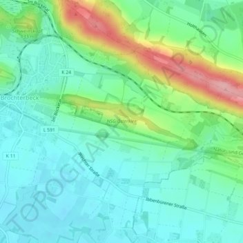
Name: Osterklee topographic map, elevation, terrain.
Average elevation: 285 ft
Minimum elevation: 167 ft
Maximum elevation: 594 ft
Make a donation
Gear up for your next adventure:
As an Amazon Associate, this site earns from qualifying purchases at no extra cost to you.