Geolocate

Huamachuco topographic map

Click on the map to display elevation.

Huamachuco

Está situada a una altitud de 3269 m s. n. m. en la vertiente oriental de la cordillera de los Andes, en un valle a 184 km de la ciudad de Trujillo.

Wikipedia (CC-BY-SA 3.0)

About this map

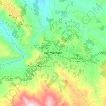
Name: Huamachuco topographic map, elevation, terrain.

Location: Huamachuco, Sánchez Carrión, La Libertad, Perú (-7.85547 -78.08871 -7.77547 -78.00871)

Average elevation: 10,673 ft

Minimum elevation: 9,114 ft

Maximum elevation: 13,635 ft

Gear up for your next adventure:

🗺️NatGeo Topo Maps - High-quality waterproof printed topographic maps of US Parks
🪵Folding Camp Saw - Compact saw for wood and campsite work
🔦Compact Flashlight - Reliable flashlight for emergencies
🔌USB Car Charger - Car charger for on‑the‑go power needs
🪶Camp Gear Gift Set - Perfect gift bundle for outdoor fans

As an Amazon Associate, this site earns from qualifying purchases at no extra cost to you.