
Thank you for supporting this site ❤️
Make a donation
Make a donation
Gear up for your next adventure:
As an Amazon Associate, this site earns from qualifying purchases at no extra cost to you.
Pachacoto topographic map
Click on the map to display elevation.
Thank you for supporting this site ❤️
Make a donation
Make a donation
Gear up for your next adventure:
As an Amazon Associate, this site earns from qualifying purchases at no extra cost to you.
About this map
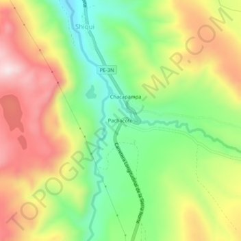
Name: Pachacoto topographic map, elevation, terrain.
Location: Pachacoto, Shiqui, Cátac, Recuay, Áncash, Perú (-9.87226 -77.42678 -9.83226 -77.38678)
Average elevation: 12,618 ft
Minimum elevation: 11,886 ft
Maximum elevation: 13,468 ft
Thank you for supporting this site ❤️
Make a donation
Make a donation
Gear up for your next adventure:
As an Amazon Associate, this site earns from qualifying purchases at no extra cost to you.