
Make a donation
Gear up for your next adventure:
As an Amazon Associate, this site earns from qualifying purchases at no extra cost to you.
Neckartenzlingen topographic map
Click on the map to display elevation.
Make a donation
Gear up for your next adventure:
As an Amazon Associate, this site earns from qualifying purchases at no extra cost to you.
Neckartenzlingen
Neckartenzlingen liegt im Neckartal an der Mündung der Erms in den Neckar, rund 25 Kilometer südlich von Stuttgart, 10 Kilometer nördlich von Reutlingen und 7 Kilometer nordwestlich des Albtraufs zwischen 288 und 415 Meter Höhe.
Make a donation
Gear up for your next adventure:
As an Amazon Associate, this site earns from qualifying purchases at no extra cost to you.
About this map
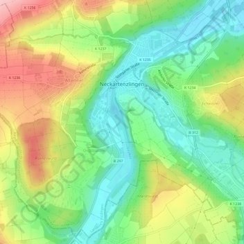
Name: Neckartenzlingen topographic map, elevation, terrain.
Average elevation: 1,138 ft
Minimum elevation: 919 ft
Maximum elevation: 1,467 ft
Make a donation
Gear up for your next adventure:
As an Amazon Associate, this site earns from qualifying purchases at no extra cost to you.
Other topographic maps
Click on a map to view its topography, its elevation and its terrain.
Egelsberg
Deutschland > Baden-Württemberg > Landkreis Esslingen > Weilheim an der Teck
Average elevation: 1,243 ft
Hofgut Tachenhausen
Deutschland > Baden-Württemberg > Landkreis Esslingen > Oberboihingen
Average elevation: 1,053 ft
Make a donation
Gear up for your next adventure:
As an Amazon Associate, this site earns from qualifying purchases at no extra cost to you.