

Susak topographic map
Click on the map to display elevation.
Susak
Located in the Kvarner Bay and southeast of the Istrian peninsula, the Croatian island of Susak is 7.4 kilometers (4.6 mi; 4.0 nmi) southwest from the island of Lošinj, 10 kilometers (6.2 mi; 5.4 nmi) south of the island of Unije, and 120 kilometers (75 mi; 65 nmi) east of the Italian coast. Susak is about 3 km (1.9 mi) long and 1.5 km (0.9 mi) wide, and covers an area of approximately 3.8 square kilometers (1.5 sq mi). Susak's highest elevation point, Garba is 98 metres (322 feet) above sea level.
About this map
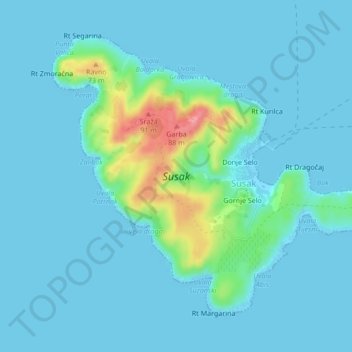
Name: Susak topographic map, elevation, terrain.
Average elevation: 43 ft
Minimum elevation: -3 ft
Maximum elevation: 308 ft