
Plants topographic map
Interactive map
Click on the map to display elevation.
About this map
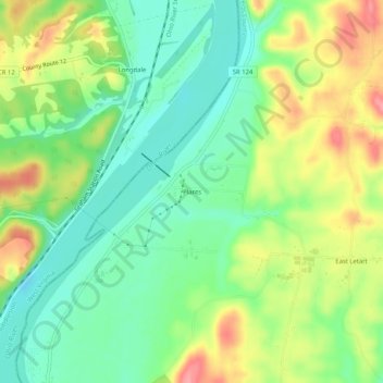
Name: Plants topographic map, elevation, terrain.
Location: Plants, Meigs County, Ohio, United States (38.89341 -81.92486 38.93341 -81.88486)
Average elevation: 650 ft
Minimum elevation: 525 ft
Maximum elevation: 837 ft
Other topographic maps
Click on a map to view its topography, its elevation and its terrain.
Racine
United States > Ohio > Meigs County
Racine, Meigs County, Ohio, United States
Average elevation: 607 ft
Rutland
United States > Ohio > Meigs County > Rutland
Rutland, Meigs County, Ohio, United States
Average elevation: 663 ft
Middleport
United States > Ohio > Meigs County > Middleport
Middleport, Meigs County, Ohio, United States
Average elevation: 673 ft