
Make a donation
Gear up for your next adventure:
As an Amazon Associate, this site earns from qualifying purchases at no extra cost to you.
Eygliers topographic map
Click on the map to display elevation.
Make a donation
Gear up for your next adventure:
As an Amazon Associate, this site earns from qualifying purchases at no extra cost to you.
About this map
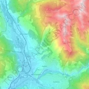
Name: Eygliers topographic map, elevation, terrain.
Average elevation: 4,757 ft
Minimum elevation: 2,861 ft
Maximum elevation: 8,802 ft
Make a donation
Gear up for your next adventure:
As an Amazon Associate, this site earns from qualifying purchases at no extra cost to you.
Other topographic maps
Click on a map to view its topography, its elevation and its terrain.
Pic Gaspard
France > Provence-Alpes-Côte d'Azur > Hautes-Alpes > Villar-d'Arêne
Average elevation: 10,318 ft
Col du Lautaret
France > Provence-Alpes-Côte d'Azur > Hautes-Alpes > Le Monêtier-les-Bains
From the west, the climb starts at Les Clapier, near Le Bourg-d'Oisans, from where the climb is 34.2 km (21.3 mi) long, gaining 1,312 m (4,304 ft) in altitude, at an average gradient of 3.8%, with the steepest section being at 7.5% in the first kilometre.
Average elevation: 7,418 ft
Les Meyries
France > Provence-Alpes-Côte d'Azur > Hautes-Alpes > Freissinières
Average elevation: 4,846 ft
Make a donation
Gear up for your next adventure:
As an Amazon Associate, this site earns from qualifying purchases at no extra cost to you.
Barre des Écrins
France > Provence-Alpes-Côte d'Azur > Hautes-Alpes > Vallouise-Pelvoux
The Barre des Écrins (French pronunciation: [baʁ dez‿ekʁɛ̃]) is a mountain in the French Alps with a peak elevation of 4,102 metres (13,458 ft). It is the highest peak of the Massif des Écrins and the Dauphiné Alps and the most southerly alpine peak in Europe that is higher than 4,000 metres. It is…
Average elevation: 10,571 ft
Lac du Sautet
France > Provence-Alpes-Côte d'Azur > Hautes-Alpes > Aspres-lès-Corps
Average elevation: 3,461 ft
Orcières-Merlette
France > Provence-Alpes-Côte d'Azur > Hautes-Alpes > Orcières
Average elevation: 6,148 ft
Ailefroide
France > Provence-Alpes-Côte d'Azur > Hautes-Alpes > Vallouise-Pelvoux
Average elevation: 6,690 ft
Make a donation
Gear up for your next adventure:
As an Amazon Associate, this site earns from qualifying purchases at no extra cost to you.
Pic Gaspard
France > Provence-Alpes-Côte d'Azur > Hautes-Alpes > Villar-d'Arêne
Average elevation: 10,318 ft
Les Gondoins
France > Provence-Alpes-Côte d'Azur > Hautes-Alpes > Les Borels
Average elevation: 5,699 ft
Pramouton
France > Provence-Alpes-Côte d'Azur > Hautes-Alpes > Saint-André-d'Embrun
Average elevation: 6,841 ft
Le Pied du Col
France > Provence-Alpes-Côte d'Azur > Hautes-Alpes > Villar-d'Arêne
Average elevation: 6,893 ft
Make a donation
Gear up for your next adventure:
As an Amazon Associate, this site earns from qualifying purchases at no extra cost to you.
Station de ski de Céüze
France > Provence-Alpes-Côte d'Azur > Hautes-Alpes > Manteyer
Average elevation: 5,184 ft
Saint-Disdier
France > Provence-Alpes-Côte d'Azur > Hautes-Alpes > Le Dévoluy
Average elevation: 4,357 ft
Villeneuve
France > Provence-Alpes-Côte d'Azur > Hautes-Alpes > La Salle-les-Alpes
Average elevation: 5,554 ft
Ctete de Praroussin
France > Provence-Alpes-Côte d'Azur > Hautes-Alpes > Abriès-Ristolas
Average elevation: 7,264 ft
Make a donation
Gear up for your next adventure:
As an Amazon Associate, this site earns from qualifying purchases at no extra cost to you.
Les Alpes
France > Provence-Alpes-Côte d'Azur > Hautes-Alpes > Saint-Marcelin
Average elevation: 3,520 ft
Make a donation
Gear up for your next adventure:
As an Amazon Associate, this site earns from qualifying purchases at no extra cost to you.
La Rousse
France > Provence-Alpes-Côte d'Azur > Hautes-Alpes > Saint-Véran
Average elevation: 8,022 ft
Ailefroide
France > Provence-Alpes-Côte d'Azur > Hautes-Alpes > Vallouise-Pelvoux
Average elevation: 6,690 ft
Make a donation
Gear up for your next adventure:
As an Amazon Associate, this site earns from qualifying purchases at no extra cost to you.
Briançon
France > Provence-Alpes-Côte d'Azur > Hautes-Alpes > Briançon > Briançon
Due to its elevation, Briançon features a warm-summer humid continental climate (Köppen : Dfb), bordering on an oceanic climate (Cfb) under the Köppen system. Summers are warm with cool nights, and winters are cold and snowy.
Average elevation: 5,364 ft
Le Petit Buëch
France > Provence-Alpes-Côte d'Azur > Hautes-Alpes > La Roche-des-Arnauds > Les Baux
Average elevation: 3,720 ft
Serre Chevalier
France > Provence-Alpes-Côte d'Azur > Hautes-Alpes > Puy-Saint-André
The maximum elevation for skiing is at Telesiege Yret at 2,800 m (9,190 ft) above sea level, and the minimum is 1,200 m (3,940 ft), a total vertical drop of 1,600 m (5,250 ft). One of the outstanding features of Serre Chevalier is the wooded nature of the slopes. The timber line is at 2,150 m (7,050 ft),…
Average elevation: 7,402 ft
Sainte-Marie
France > Provence-Alpes-Côte d'Azur > Hautes-Alpes > Vars > Sainte-Marie
Average elevation: 6,585 ft
Make a donation
Gear up for your next adventure:
As an Amazon Associate, this site earns from qualifying purchases at no extra cost to you.
Notre-Dame du Laus
France > Provence-Alpes-Côte d'Azur > Hautes-Alpes > Saint-Étienne-le-Laus
Average elevation: 3,120 ft
Torrent du Courou
France > Provence-Alpes-Côte d'Azur > Hautes-Alpes > Ancelle
Average elevation: 6,430 ft
Make a donation
Gear up for your next adventure:
As an Amazon Associate, this site earns from qualifying purchases at no extra cost to you.
Les Chaussendents
France > Provence-Alpes-Côte d'Azur > Hautes-Alpes > La Chapelle-en-Valgaudémar
Average elevation: 5,312 ft
Brunissard
France > Provence-Alpes-Côte d'Azur > Hautes-Alpes > Arvieux > Brunissard
Average elevation: 6,919 ft
Château-Queyras
France > Provence-Alpes-Côte d'Azur > Hautes-Alpes > Château-Ville-Vieille
Average elevation: 5,620 ft
Make a donation
Gear up for your next adventure:
As an Amazon Associate, this site earns from qualifying purchases at no extra cost to you.
Molines en Champsaur
France > Provence-Alpes-Côte d'Azur > Hautes-Alpes > La Motte-en-Champsaur
Average elevation: 5,751 ft
Pierre-Grosse
France > Provence-Alpes-Côte d'Azur > Hautes-Alpes > Molines-en-Queyras
Average elevation: 6,972 ft