
Make a donation
Gear up for your next adventure:
As an Amazon Associate, this site earns from qualifying purchases at no extra cost to you.
Serra do Imeri topographic map
Click on the map to display elevation.
Make a donation
Gear up for your next adventure:
As an Amazon Associate, this site earns from qualifying purchases at no extra cost to you.
About this map
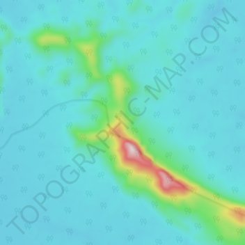
Name: Serra do Imeri topographic map, elevation, terrain.
Average elevation: 551 ft
Minimum elevation: 331 ft
Maximum elevation: 2,175 ft
Make a donation
Gear up for your next adventure:
As an Amazon Associate, this site earns from qualifying purchases at no extra cost to you.
Other topographic maps
Click on a map to view its topography, its elevation and its terrain.
Make a donation
Gear up for your next adventure:
As an Amazon Associate, this site earns from qualifying purchases at no extra cost to you.
Aldeia Indígena São José de Marabitanas
Brasil > Amazonas > São Gabriel da Cachoeira
Average elevation: 269 ft
Make a donation
Gear up for your next adventure:
As an Amazon Associate, this site earns from qualifying purchases at no extra cost to you.
Maloca Sao Pedro
Brasil > Amazonas > São Gabriel da Cachoeira > Maloca Sao Pedro
Average elevation: 466 ft
Comunidade Santo Antonio
Brasil > Amazonas > São Gabriel da Cachoeira > Comunidade Santo Antonio
Average elevation: 279 ft
Make a donation
Gear up for your next adventure:
As an Amazon Associate, this site earns from qualifying purchases at no extra cost to you.