
Make a donation
Gear up for your next adventure:
As an Amazon Associate, this site earns from qualifying purchases at no extra cost to you.
Drübeck topographic map
Click on the map to display elevation.
Make a donation
Gear up for your next adventure:
As an Amazon Associate, this site earns from qualifying purchases at no extra cost to you.
Drübeck
Drübeck liegt auf einer Höhe von 258 m ü. NN am Nordrand des Harzes zwischen Darlingerode im Osten und Ilsenburg (Harz) im Westen. Südlich des Dorfes liegt Oehrenfeld.
Make a donation
Gear up for your next adventure:
As an Amazon Associate, this site earns from qualifying purchases at no extra cost to you.
About this map
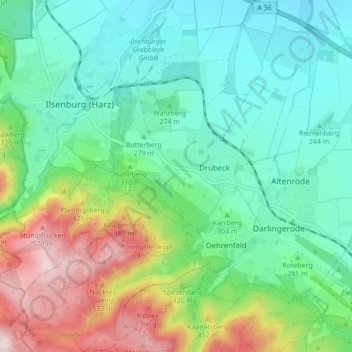
Name: Drübeck topographic map, elevation, terrain.
Average elevation: 1,053 ft
Minimum elevation: 659 ft
Maximum elevation: 1,995 ft
Make a donation
Gear up for your next adventure:
As an Amazon Associate, this site earns from qualifying purchases at no extra cost to you.
Other topographic maps
Click on a map to view its topography, its elevation and its terrain.
Untere Zeterklippen
Deutschland > Sachsen-Anhalt > Landkreis Harz > Ilsenburg
Average elevation: 2,503 ft