Geolocate

Callaway topographic map

Click on the map to display elevation.

About this map

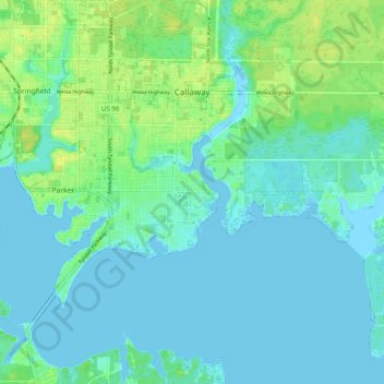
Name: Callaway topographic map, elevation, terrain.

Location: Callaway, Bay County, Florida, 32404, United States (30.09328 -85.60504 30.16762 -85.50583)

Average elevation: 16 ft

Minimum elevation: -16 ft

Maximum elevation: 59 ft

Bay County trails, hiking, mountain biking, running and outdoor activities

Other topographic maps

Click on a map to view its topography, its elevation and its terrain.

Youngstown

United States > Florida > Bay County

Average elevation: 79 ft

Fountain

United States > Florida > Bay County

Average elevation: 167 ft

Millville

United States > Florida > Bay County > Panama City

Average elevation: 30 ft

Southport

United States > Florida > Bay County

Average elevation: 20 ft

Laguna Beach

United States > Florida > Bay County

Average elevation: 7 ft

Saint Andrew

United States > Florida > Bay County > Panama City

Average elevation: 16 ft

Bayview

United States > Florida > Bay County

Average elevation: 10 ft

Youngstown

United States > Florida > Bay County

Average elevation: 79 ft

Fountain

United States > Florida > Bay County

Average elevation: 167 ft

Long Point

United States > Florida > Bay County > Parker

Average elevation: 7 ft

Lake Powell Park

United States > Florida > Bay County

Average elevation: 10 ft

Gear up for your next adventure:

🔦Powerful Headlamps - Ultra-bright hands-free lighting for night navigation
🛰️Handheld GPS Units - Professional satellite navigators for precise backcountry mapping
🦶Carbon Trekking Poles - Reduce knee impact on steep descents with ultra-light poles
🦺Reflective Outdoor Gear - Safety gear for low‑light conditions
🧭Map Reading Tools - Tools and kits for map navigation

As an Amazon Associate, this site earns from qualifying purchases at no extra cost to you.