
Make a donation
Gear up for your next adventure:
As an Amazon Associate, this site earns from qualifying purchases at no extra cost to you.
Baltimore topographic map
Click on the map to display elevation.
Make a donation
Gear up for your next adventure:
As an Amazon Associate, this site earns from qualifying purchases at no extra cost to you.
About this map
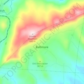
Name: Baltimore topographic map, elevation, terrain.
Location: Baltimore, Windsor County, Vermont, United States (43.34527 -72.60708 43.38149 -72.53868)
Average elevation: 1,155 ft
Minimum elevation: 643 ft
Maximum elevation: 2,057 ft
Windsor County trails, hiking, mountain biking, running and outdoor activities
Make a donation
Gear up for your next adventure:
As an Amazon Associate, this site earns from qualifying purchases at no extra cost to you.
Other topographic maps
Click on a map to view its topography, its elevation and its terrain.
Make a donation
Gear up for your next adventure:
As an Amazon Associate, this site earns from qualifying purchases at no extra cost to you.
North Springfield
United States > Vermont > Windsor County > Springfield > North Springfield
Average elevation: 620 ft
Make a donation
Gear up for your next adventure:
As an Amazon Associate, this site earns from qualifying purchases at no extra cost to you.
Bridgewater Corners
United States > Vermont > Windsor County > Bridgewater
Average elevation: 1,273 ft
Make a donation
Gear up for your next adventure:
As an Amazon Associate, this site earns from qualifying purchases at no extra cost to you.