
Make a donation
Gear up for your next adventure:
As an Amazon Associate, this site earns from qualifying purchases at no extra cost to you.
Rojales topographic map
Click on the map to display elevation.
Make a donation
Gear up for your next adventure:
As an Amazon Associate, this site earns from qualifying purchases at no extra cost to you.
About this map
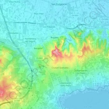
Name: Rojales topographic map, elevation, terrain.
Average elevation: 79 ft
Minimum elevation: -20 ft
Maximum elevation: 397 ft
Make a donation
Gear up for your next adventure:
As an Amazon Associate, this site earns from qualifying purchases at no extra cost to you.
Other topographic maps
Click on a map to view its topography, its elevation and its terrain.
Torremendo
Spanje > Valencia > el Baix Segura / La Vega Baja del Segura > Orihuela
Average elevation: 417 ft
Barbarroja
Spanje > Valencia > el Baix Segura / La Vega Baja del Segura > Orihuela
Average elevation: 1,526 ft
Villa Martín
Spanje > Valencia > el Baix Segura / La Vega Baja del Segura > Orihuela
Average elevation: 243 ft
La Murada
Spanje > Valencia > el Baix Segura / La Vega Baja del Segura > Orihuela
Average elevation: 272 ft
Make a donation
Gear up for your next adventure:
As an Amazon Associate, this site earns from qualifying purchases at no extra cost to you.