
Lakesite topographic map
Click on the map to display elevation.
About this map
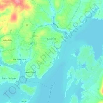
Name: Lakesite topographic map, elevation, terrain.
Average elevation: 735 ft
Minimum elevation: 659 ft
Maximum elevation: 991 ft
Hamilton County trails, hiking, mountain biking, running and outdoor activities
Other topographic maps
Click on a map to view its topography, its elevation and its terrain.
Spring Valley
United States > Tennessee > Hamilton County > Chattanooga > Red Bank
Average elevation: 1,047 ft
Tennesse Riverwalk
United States > Tennessee > Hamilton County > Chattanooga
Average elevation: 679 ft
Glenwood
United States > Tennessee > Hamilton County > Chattanooga > Ridgeside
Average elevation: 751 ft
Soddy-Daisy
United States > Tennessee > Hamilton County > Soddy-Daisy > Soddy-Daisy
Average elevation: 1,007 ft
Forest Highlands
United States > Tennessee > Hamilton County > Chattanooga > Forest Highlands
Average elevation: 784 ft
Alpine Heights
United States > Tennessee > Hamilton County > Chattanooga > Red Bank
Average elevation: 817 ft
Morrison Springs
United States > Tennessee > Hamilton County > Chattanooga > Red Bank
Average elevation: 1,073 ft
Pine Harbor Heights
United States > Tennessee > Hamilton County > Soddy-Daisy
Average elevation: 781 ft
Knollwood
United States > Tennessee > Hamilton County > Chattanooga > Red Bank
Average elevation: 804 ft