
Chattanooga topographic map
Click on the map to display elevation.
About this map
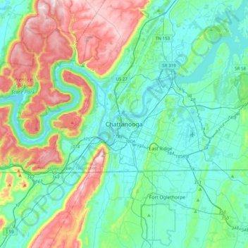
Name: Chattanooga topographic map, elevation, terrain.
Location: Chattanooga, Hamilton County, Tennessee, 818, United States (34.88572 -85.46949 35.20572 -85.14949)
Average elevation: 1,020 ft
Minimum elevation: 620 ft
Maximum elevation: 2,169 ft
Hamilton County trails, hiking, mountain biking, running and outdoor activities
Other topographic maps
Click on a map to view its topography, its elevation and its terrain.
Tennesse Riverwalk
United States > Tennessee > Hamilton County > Chattanooga
Average elevation: 679 ft