
Make a donation
Gear up for your next adventure:
As an Amazon Associate, this site earns from qualifying purchases at no extra cost to you.
Jeker topographic map
Click on the map to display elevation.
Make a donation
Gear up for your next adventure:
As an Amazon Associate, this site earns from qualifying purchases at no extra cost to you.
Jeker
De Jeker (Frans: Geer of Jaer; Waals: Djer; Latijn: Jecora; Maastrichts: Eker) is een rivier die in het Belgische Lens-Saint-Servais nabij Borgworm (Frans: Waremme) ontspringt, door een groot gedeelte van Haspengouw stroomt en bij de Nederlandse stad Maastricht in de Maas vloeit (coördinaten: 50° 51′ NB, 5° 42′ OL). Nabij Tongeren en Bitsingen (Frans: Bassenge) kruist de Jeker de Nederlands-Franse taalgrens. De Jeker is ongeveer 55 km lang. Met name nabij de monding in de Maas heeft het Jekerdal vrij steile hellingen, in sommige gevallen bedekt met hellingbossen. Het grootste hoogteverschil (nabij Bassenge) bedraagt 75 meter.
Make a donation
Gear up for your next adventure:
As an Amazon Associate, this site earns from qualifying purchases at no extra cost to you.
About this map
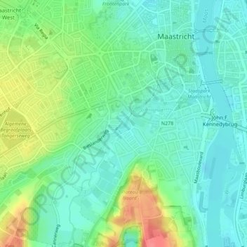
Name: Jeker topographic map, elevation, terrain.
Average elevation: 210 ft
Minimum elevation: 141 ft
Maximum elevation: 361 ft
Make a donation
Gear up for your next adventure:
As an Amazon Associate, this site earns from qualifying purchases at no extra cost to you.
Other topographic maps
Click on a map to view its topography, its elevation and its terrain.
Maastricht
Nederland > Limburg > Maastricht
Maastricht ligt in het zuiden van Nederland. De stad ligt aan de voet van de Sint-Pietersberg, tussen het Plateau van Margraten, het Plateau van Caestert en de Haspengouw, op de plaats waar de rivier de Jeker in de Maas uitmondt. Het centrum van de stad ligt op een hoogte van ca. 50 meter boven NAP. De…
Average elevation: 331 ft
Itteren
Nederland > Limburg > Maastricht
Itteren ligt op de rechteroever van de Maas, op een hoogte van ongeveer 43 meter. Het ligt sinds de aanleg van het Julianakanaal omstreeks 1930 op een langgerekt eiland, door enkele bruggen met het achterland verbonden.
Average elevation: 151 ft
Make a donation
Gear up for your next adventure:
As an Amazon Associate, this site earns from qualifying purchases at no extra cost to you.