Geolocate

Eltville am Rhein topographic map

Click on the map to display elevation.

About this map

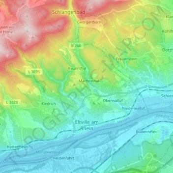
Name: Eltville am Rhein topographic map, elevation, terrain.

Location: Eltville am Rhein, Rheingau-Taunus-Kreis, Hesse, Germany (50.00509 8.00292 50.09499 8.15827)

Average elevation: 764 ft

Minimum elevation: 259 ft

Maximum elevation: 1,926 ft

Other topographic maps

Click on a map to view its topography, its elevation and its terrain.

Dickschied

Germany > Hesse > Rheingau-Taunus-Kreis

Average elevation: 1,175 ft

Kalte Herberge

Germany > Hesse > Rheingau-Taunus-Kreis > Hallgarten

Average elevation: 1,699 ft

Hohe Wurzel

Germany > Hesse > Rheingau-Taunus-Kreis > Taunusstein

Average elevation: 1,670 ft

Gear up for your next adventure:

📶Satellite Messenger - Communication device off‑grid
📻Weather Alert Radios - Stay informed of storm risks while off-the-grid
🏕️Tent Footprint - Protect your tent base from wear
🔦Powerful Headlamps - Ultra-bright hands-free lighting for night navigation
🌧️Backpack Rain Cover - Keep gear dry in wet weather

As an Amazon Associate, this site earns from qualifying purchases at no extra cost to you.