
Petrópolis topographic map
Click on the map to display elevation.
Petrópolis
Petrópolis has a tropical highland climate (Köppen climate classification: Cwa) caused by elevation with humid summers. The rainfall is approximately 1,383 mm (54.4 in) per annum.
About this map
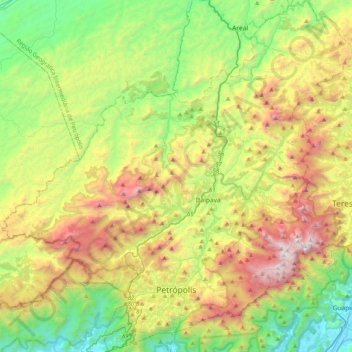
Name: Petrópolis topographic map, elevation, terrain.
Location: Petrópolis, Rio de Janeiro, Southeast Region, Brazil (-22.57333 -43.37730 -22.20252 -42.97798)
Average elevation: 2,733 ft
Minimum elevation: 39 ft
Maximum elevation: 7,313 ft
Other topographic maps
Click on a map to view its topography, its elevation and its terrain.
Sugarloaf
Brazil > Rio de Janeiro > Região Metropolitana do Rio de Janeiro > Rio de Janeiro
Average elevation: 56 ft
Corcovado
Brazil > Rio de Janeiro > Região Metropolitana do Rio de Janeiro > Rio de Janeiro
Average elevation: 725 ft
Quinta da Boa Vista
Brazil > Rio de Janeiro > Região Metropolitana do Rio de Janeiro > Rio de Janeiro
Average elevation: 62 ft
Praça Heitor Bastos Tigre
Brazil > Rio de Janeiro > Região Metropolitana do Rio de Janeiro > Rio de Janeiro
Average elevation: 23 ft
Vale das Pedrinhas
Brazil > Rio de Janeiro > Região Metropolitana do Rio de Janeiro > Guapimirim
Average elevation: 26 ft
Morro da Babilônia
Brazil > Rio de Janeiro > Região Metropolitana do Rio de Janeiro > Rio de Janeiro
Average elevation: 95 ft
Morro da Babilônia
Brazil > Rio de Janeiro > Região Metropolitana do Rio de Janeiro > Rio de Janeiro
Average elevation: 95 ft
Morro da Babilônia
Brazil > Rio de Janeiro > Região Metropolitana do Rio de Janeiro > Rio de Janeiro
Average elevation: 95 ft
Manuel de Morais
Brazil > Rio de Janeiro > Trajano de Moraes > Visconde de Imbé
Average elevation: 1,188 ft