
Blackbeard Island topographic map
Interactive map
Click on the map to display elevation.
About this map
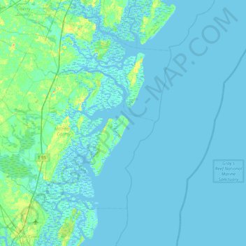
Name: Blackbeard Island topographic map, elevation, terrain.
Location: Blackbeard Island, McIntosh County, Georgia, United States (31.19606 -81.51593 31.83606 -80.87593)
Average elevation: 7 ft
Minimum elevation: -16 ft
Maximum elevation: 66 ft
Other topographic maps
Click on a map to view its topography, its elevation and its terrain.
Harris Neck National Wildlife Refuge
United States > Georgia > McIntosh County
Harris Neck National Wildlife Refuge, McIntosh County, Georgia, United States
Average elevation: 10 ft
Black Island
United States > Georgia > McIntosh County
Black Island, McIntosh County, Georgia, United States
Average elevation: 7 ft
Darien
United States > Georgia > McIntosh County
Darien, McIntosh County, Georgia, 31305, United States
Average elevation: 10 ft
Pico Island
United States > Georgia > McIntosh County > Darien
Pico Island, Darien, McIntosh County, Georgia, 31305, United States
Average elevation: 13 ft