Geolocate

Kingsley topographic map

Click on the map to display elevation.

About this map

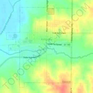
Name: Kingsley topographic map, elevation, terrain.

Location: Kingsley, Plymouth County, Iowa, United States (42.57427 -95.98316 42.59788 -95.95725)

Average elevation: 1,266 ft

Minimum elevation: 1,194 ft

Maximum elevation: 1,368 ft

Plymouth County trails, hiking, mountain biking, running and outdoor activities

Other topographic maps

Click on a map to view its topography, its elevation and its terrain.

James

United States > Iowa > Plymouth County

Average elevation: 1,194 ft

Gear up for your next adventure:

🦟Ultrasonic Repellers - Create a bug-free zone at your camp or rest stop
🛰️Handheld GPS Units - Professional satellite navigators for precise backcountry mapping
🪓Survival Multi‑Tool - Versatile tool for camp and trail tasks
🦶Carbon Trekking Poles - Reduce knee impact on steep descents with ultra-light poles
🧯Emergency Survival Kit - All‑in‑one survival essentials for the backcountry

As an Amazon Associate, this site earns from qualifying purchases at no extra cost to you.