
Torres topographic map
Click on the map to display elevation.
Torres
Torres is part of the Metropolitan Mesoregion of Porto Alegre and the Osório Microregion. It is located at a latitude of 29º20'34" south and a longitude of 49º43'39" west, at an altitude of 16 meters. It has an area of 161.624 km². It is 197 km from Porto Alegre and 280 km from Florianópolis. Its borders are the municipality of Passo de Torres (SC) to the north, Arroio do Sal to the south, Mampituba, Dom Pedro de Alcântara, and Morrinhos do Sul to the west, and the Atlantic Ocean to the east.
About this map
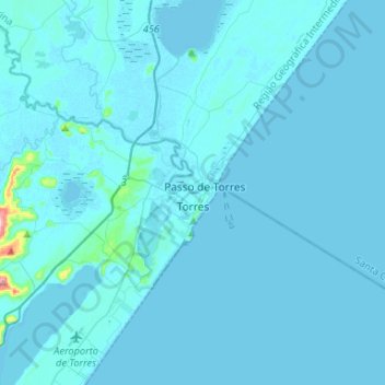
Name: Torres topographic map, elevation, terrain.
Location: Torres, Rio Grande do Sul, South Region, 95560-000, Brazil (-29.44359 -49.90155 -29.21412 -49.70345)
Average elevation: 20 ft
Minimum elevation: -13 ft
Maximum elevation: 768 ft
Other topographic maps
Click on a map to view its topography, its elevation and its terrain.
Porto Alegre
Brazil > Rio Grande do Sul > Metropolitan Region of Porto Alegre > Porto Alegre
Porto Alegre has a long coastline on the Guaíba Lake, and its topography is punctuated by 40 hills. In the lake, a vast body of water, a maze of islands facing the city creates an archipelago where a unique ecosystem gives shelter to abundant wildlife. The city area concentrates 28% of the native flora of Rio…
Average elevation: 89 ft
Pelotas
Brazil > Rio Grande do Sul > Aglomeração Urbana do Sul > Pelotas
As it is situated on a plain near the ocean, the urban area lies on a low elevation, being, on average, 7 meters (23 ft) above sea level. The interior of the municipality is on a plateau called Serras de Sudeste (Southeastern Mountain Ranges). Consequently, the altitude in Pelotas' rural area reaches 429…
Average elevation: 59 ft
Estrada Carlos Dreyer
Brazil > Rio Grande do Sul > Metropolitan Region of Porto Alegre > Igrejinha
Average elevation: 2,041 ft
Fazenda Capão do Capim
Brazil > Rio Grande do Sul > São Francisco de Paula
Average elevation: 3,159 ft