
Thank you for supporting this site ❤️
Make a donation
Make a donation
Gear up for your next adventure:
As an Amazon Associate, this site earns from qualifying purchases at no extra cost to you.
Kebnekaise topographic map
Click on the map to display elevation.
Thank you for supporting this site ❤️
Make a donation
Make a donation
Gear up for your next adventure:
As an Amazon Associate, this site earns from qualifying purchases at no extra cost to you.
About this map
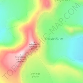
Name: Kebnekaise topographic map, elevation, terrain.
Location: Kebnekaise, Kiruna kommun, Norrbotten County, Sweden (67.90462 18.52923 67.90544 18.54020)
Average elevation: 5,433 ft
Minimum elevation: 4,508 ft
Maximum elevation: 6,942 ft
Thank you for supporting this site ❤️
Make a donation
Make a donation
Gear up for your next adventure:
As an Amazon Associate, this site earns from qualifying purchases at no extra cost to you.